Geo Elevation for Mac
Any route. Its elevation profile. On your Mac.
Is that walk hilly? How much climbing is in the ride? Where does the trail drop to the river? Geo Elevation for Mac answers on a map: click a few points along the route and the terrain under them draws itself as a chart, with the numbers a planner needs. It is the Mac-only edition of Geo Elevation, sold on its own since 2016, and it is the same app: a sample every 30 metres, the climb, the descent and the grade, and the terrain itself in 3D.

Mac
One purchase. No account, no subscription.
Click the points. The profile draws itself.
Click the map to drop a point, and again where the route bends. A second after your last edit the chart is back: one sample every 30 metres along the path, up to a thousand of them, so a short steep bank reads as a bank and a mountain reads as a mountain. The profile passes through every pin you placed. Drag a pin with a loupe that shows exactly where it sits, click the small dot on an edge to add a point there, click a pin and delete it from its callout, or press ⌫. Every step is undoable with ⌘Z. Type a coordinate to place a point exactly.
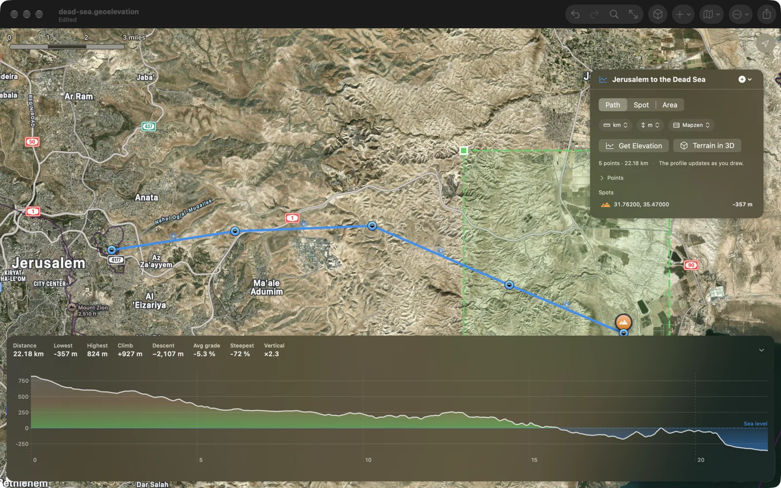
A chart that tells the truth
Sea level is a line, and water shows as water: a route from Jerusalem down to the Dead Sea ends 357 metres below the line, in blue. Above the chart sit distance, lowest and highest point, total climb and descent, the average grade and the steepest hundred metres. Move along the chart and a ring on the map shows where you are. Drag across a climb to zoom into it; double-click to see it all.
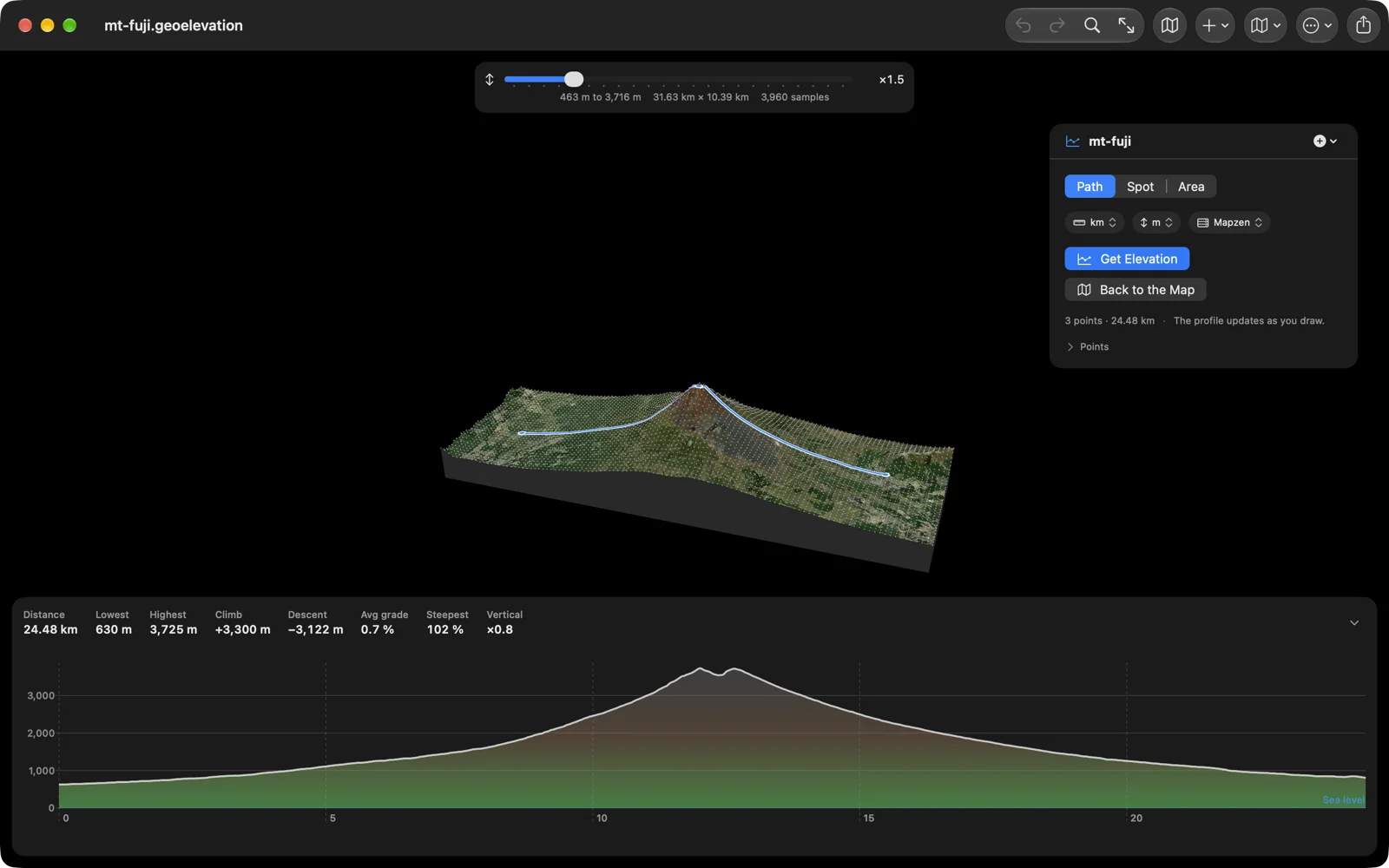
The terrain in 3D
One press samples the ground around your path, thousands of points, and shows it as a real surface with the map imagery draped over it and your path drawn on top. Drag to turn it, scroll to zoom, raise the exaggeration to see a gentle hill, hover a sample to read its height. Move along the chart and a marker walks the surface.
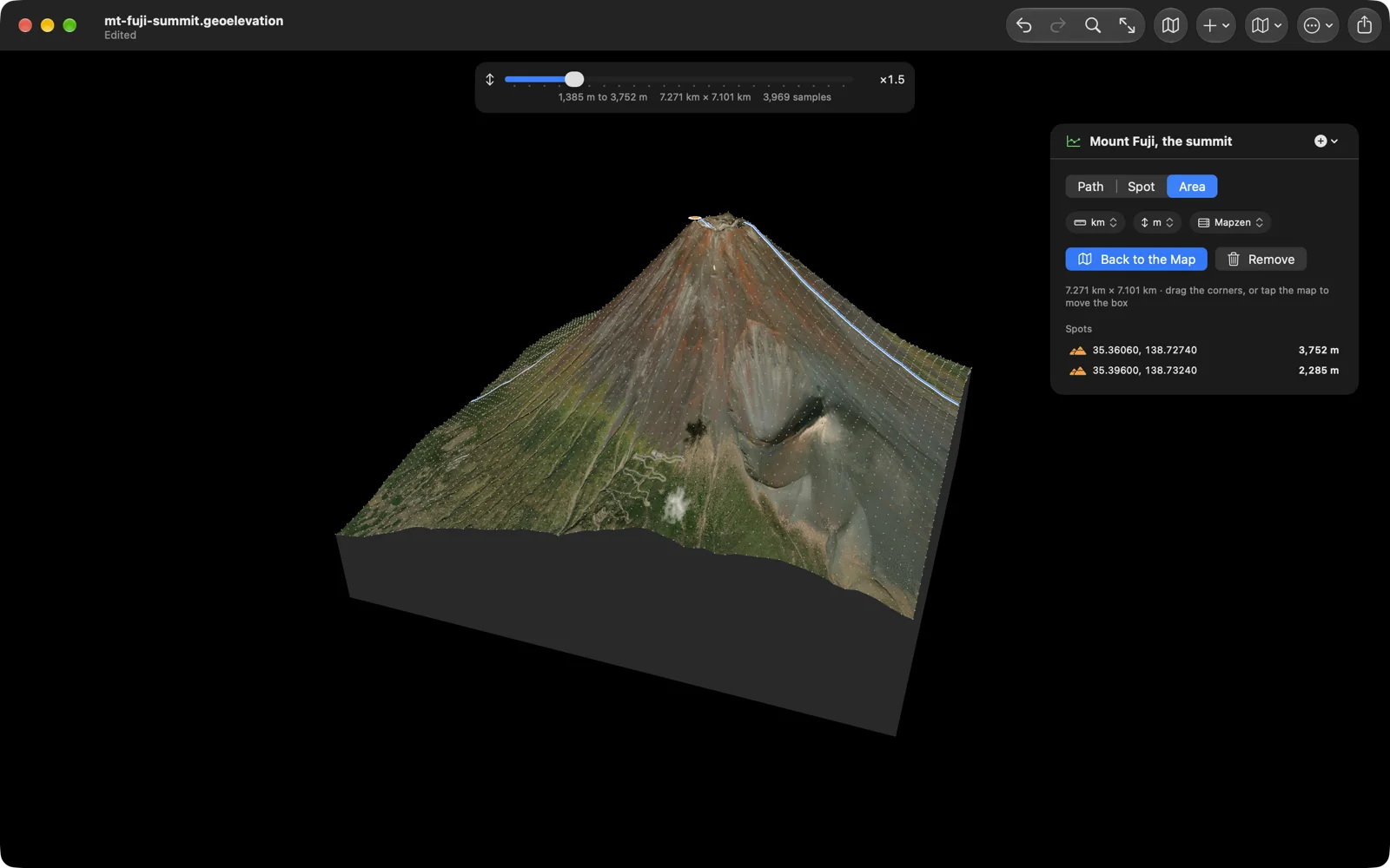
Or draw the area yourself
A path is a line, and a line has no edges. Switch to Area, drag a box around the ground you care about, the summit, the valley or the whole climb, and see just that: every sample inside the box, nothing outside it.
Spot heights
Click anywhere for the elevation of that one point. A spot stays on the map with its height, is listed under the path’s points, and exports with them.
Every point, written down
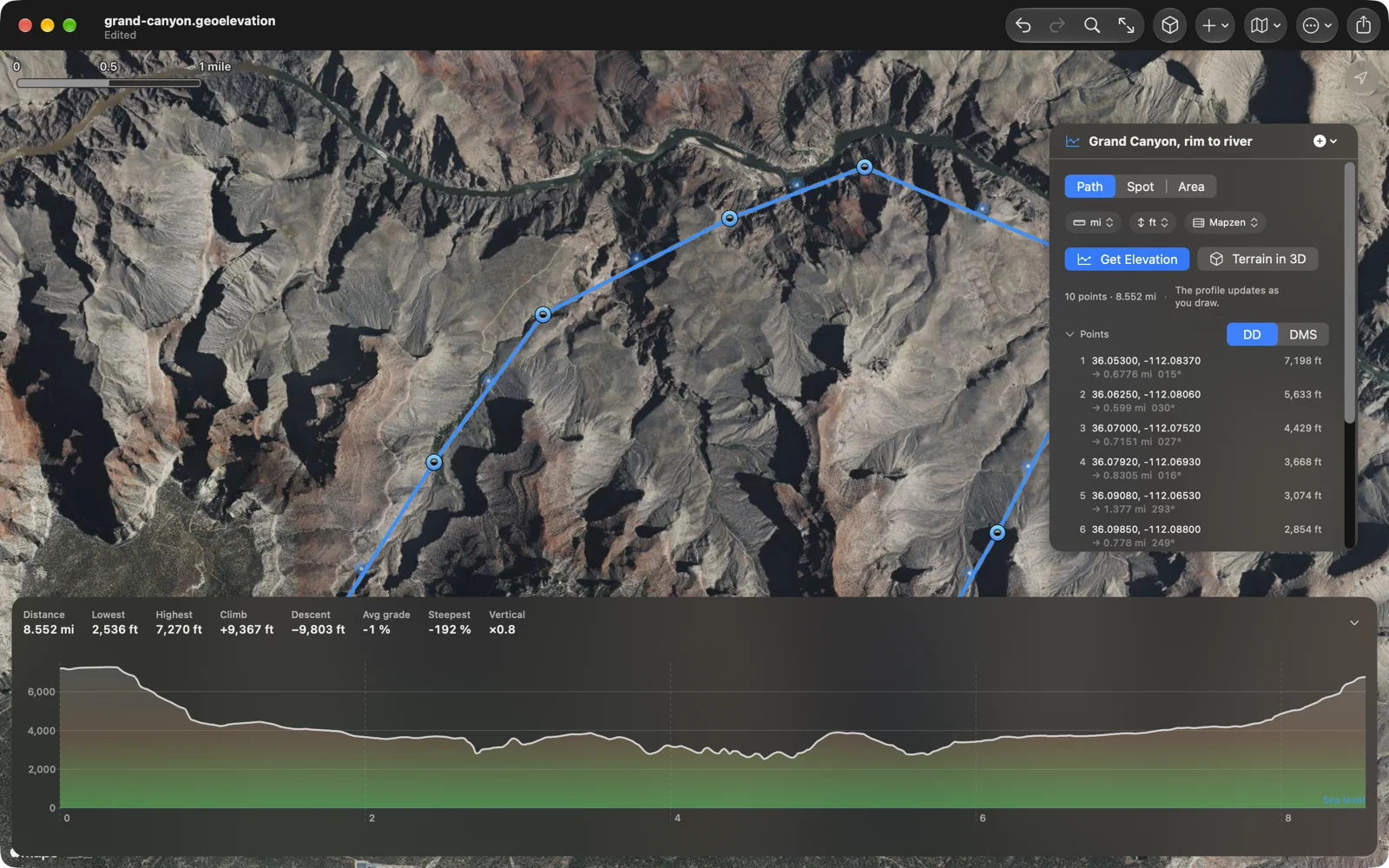
The panel lists every point with its coordinates, in decimal degrees or in degrees, minutes and seconds, its elevation, and the length and bearing of the leg to the next one. Click a row and the map goes there. Search for a place to jump the map across the world.
In and out
Import a GPX track from a watch, a KML route from Google Earth, or GeoJSON from a GIS: drop the file on the map. Every .elevation file this app has written since 2016 opens as it always did. Export the profile as GPX with elevations, as CSV for a spreadsheet, as GeoJSON, as an image of the map and the chart, or as a PDF report with the numbers and every point, and print it with ⌘P. The document itself is GeoJSON, so anything that reads GeoJSON reads it.
Your units, your map
Kilometres or miles, metres or feet: each document remembers its own, so the Grand Canyon stays in feet while the Alps stay in metres. Standard, satellite, hybrid and 3D map styles, also per document. Files live where you put them, in iCloud Drive if you like, and they open in Geo Elevation on the phone too.
Made for the Mac
Documents open in windows, autosave and keep versions. The menu bar has the whole app in it: ⌘1, ⌘2 and ⌘3 switch between drawing a path, spot heights and a 3D area, ⌘E fetches the profile, ⌘⇧T shows the terrain, ⌘F searches for a place, ⌘0 fits the map to the path, ⌫ deletes the selected point, ⌘P prints, ⌘, opens the settings. Drag the terrain to turn it and scroll to zoom. In English, German, French, Spanish and Japanese.
No file handy? Try these
Real documents, free to use. Download one and open it with Geo Elevation for Mac.
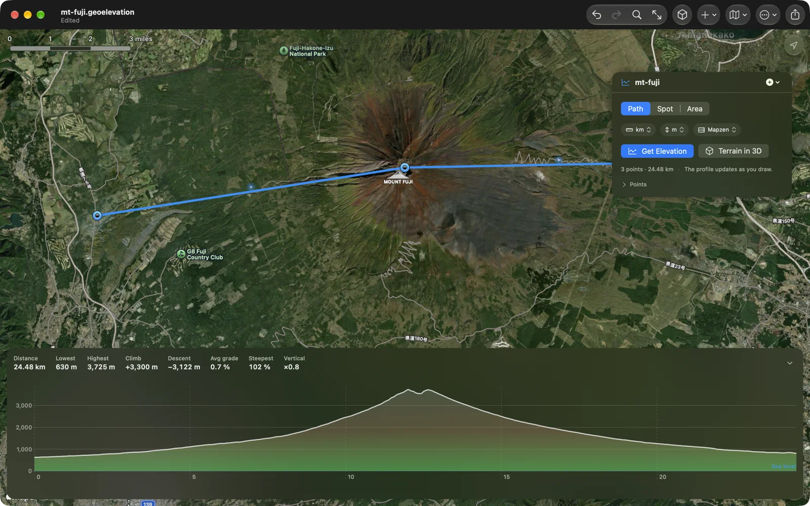
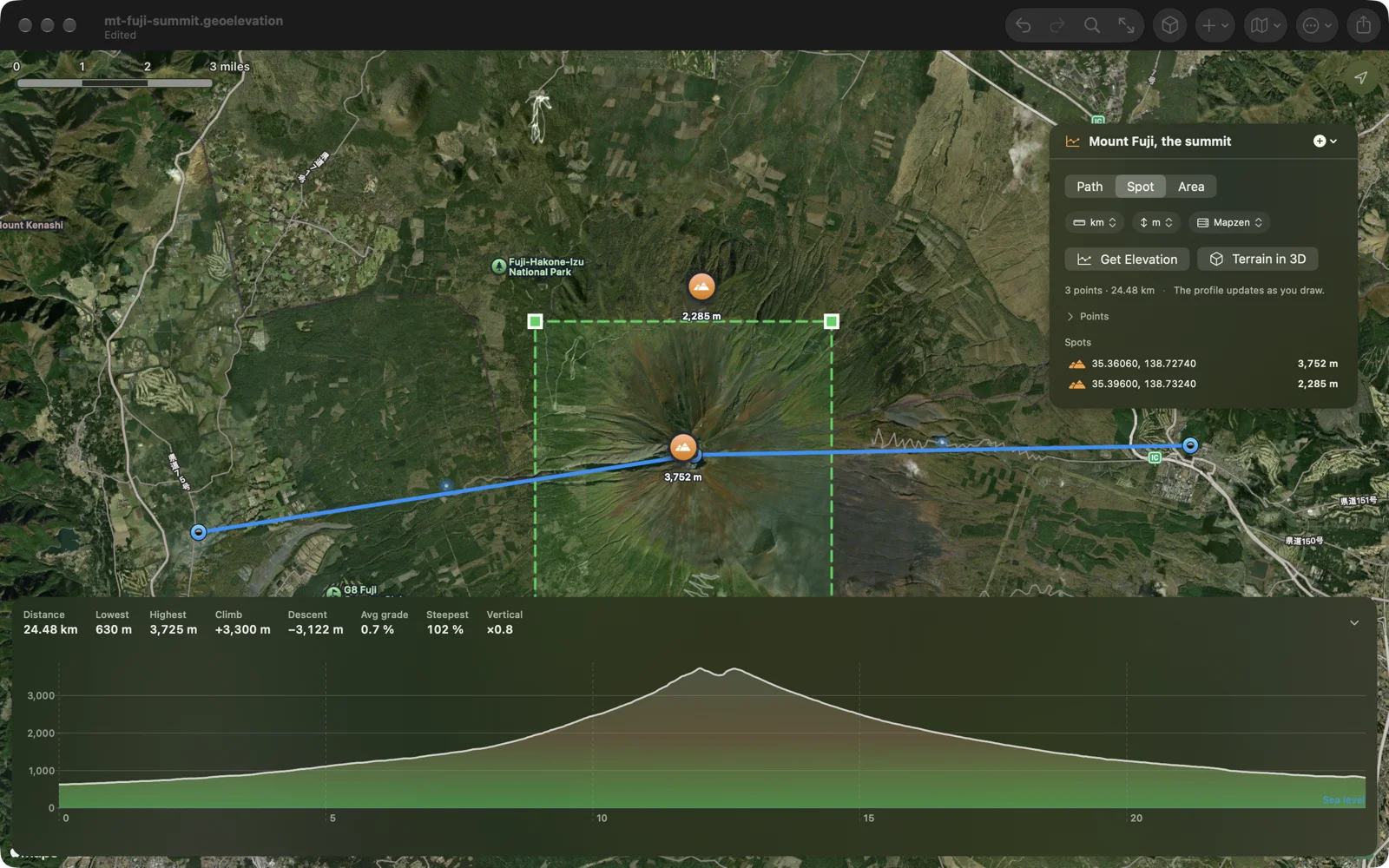
- Mount Fuji: a 24-kilometre line over the summit, 3,300 metres of climbing.
- The summit of Mount Fuji: the same line with a 7-kilometre area around the crater, ready for the terrain in 3D, and two spot heights.
- Jerusalem to the Dead Sea: 22 kilometres downhill to 357 metres below sea level.
- Grand Canyon, rim to river: ten points down the canyon, in miles and feet.
- Amalfi Coast: 658 kilometres of Italian coast in 34 points, the one that spreads a thousand samples the widest.
Yours stays yours
Geo Elevation for Mac has no account and no tracking. Your routes are files on your Mac, and in your iCloud Drive if you put them there. The only things that leave the Mac are the coordinates of the path you ask about, sent to our own elevation server to look up the heights (ASTER and Mapzen data at 30 metres, worldwide), the map tiles Apple Maps draws, and the place search you type. One purchase, no subscription, no in-app purchases.
Questions people ask
Which Geo Elevation should I buy on the Mac? Either one: they are the same app with the same features, and they get the same updates. Geo Elevation is one purchase for iPhone, iPad, Mac and Apple Vision Pro. Geo Elevation for Mac, this page, is the edition we have sold on its own since 2016, for people who only want the Mac app or who already own it. If you own one of them, you have everything; nobody needs both.
I bought Geo Elevation for Mac years ago. Do I pay again? No. Everything on this page comes to the app you own as a free update from the App Store, and it opens every file you made with it.
How do I get the elevation profile of a route? Open Geo Elevation for Mac, find the place by search or by scrolling, and click the points of the route in order. The profile appears after the second point and redraws itself as you add or move points. Switch the units on the panel.
How accurate is it? The heights come from ASTER and Mapzen, global elevation models with one value every 30 metres, and the profile samples your path at that same spacing, so a 30-metre knoll shows and nothing between the samples is invented. The data is a model of the ground, not a survey: expect a few metres either way, more on steep slopes and in cities.
Can I import a track from my watch? Yes. Import GPX, KML and GeoJSON: a track from a watch or a bike computer, a route from Google Earth, a line from a GIS. The app samples the ground along it, draws the profile, and exports the same track back out with elevations.
Does it work without a connection? Editing does; fetching the heights and loading new map tiles need one.
Is there a web version? Yes, Geo Elevation on geosq.com draws the profile of a path in any browser, free. The app adds documents, the terrain in 3D, import, export and the Mac menus.
What changed lately? The newest work is written up in the release post.