Geo Elevation 2.3: can you see it from here?
A question came in through the contact form on this site: from the high ground around Charlotte, can you see Mount Mitchell? It is the highest summit east of the Mississippi, 86 miles away in a straight line.
Geo Elevation could not say. It could draw the profile, and the profile looked hopeful: the summit stands at the far end, well above anything in between. But a profile draws the ground on a flat line, and the Earth is not flat. Over 86 miles it curves away about 4,300 feet below a level line, even with the usual allowance for the air bending the light. Whether the summit clears the ridges in between depends on that curve, and a chart that leaves it out cannot answer. So I built one that puts it in.
Line of sight
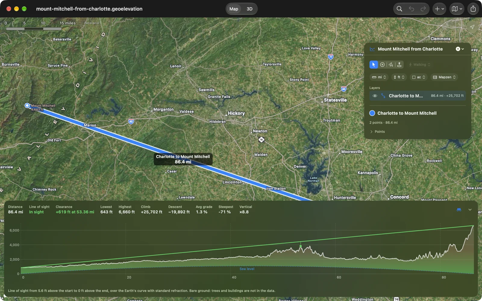
Draw a straight path between two places and press the binoculars beside the chart. The ground is lifted by the curve of the Earth, sea level becomes the arc underneath it, and a line runs from your eye above the first point to the top of whatever stands on the last one: green while it clears, orange from where the ground gets in the way, with a dot on the tightest spot and the clearance in the numbers above the chart.
The answer for Charlotte: in sight, with 619 feet to spare over the South Mountains, 53 miles out. On a clear day the summit is there.
Finding that tight spot took more thought than drawing the line. Measured in feet, the closest the line comes to the ground is nearly always right under your own eye, which tells you nothing. Measured as an angle, from both ends, it is the ridge that actually decides.
Sea, or land below sea level
The same reader also asked about Death Valley, and that turned up a second problem. Below sea level, an elevation model cannot tell the seabed from a dry basin: both are just negative numbers. So wherever a path dips below the line, the app now asks OpenStreetMap’s coastline whether it is sea or land. The ocean is drawn as sea, Death Valley as the dry ground it is, on every chart and report, line of sight or not. Until the coastline answers, a line of sight over ground below sea level says it can’t tell rather than guess.
The view from any point
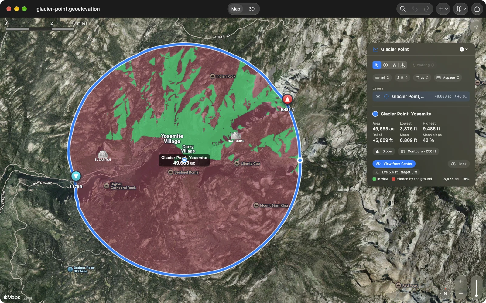
Once a line could answer, a circle could too. Draw a circle and turn on View from Center: every piece of ground its center can see turns green, everything the terrain hides turns red, on the map and on the 3D block, with the area and the share in view. You set the height of your eye and of what you are looking for, a person, a roof, a tower. From Glacier Point in Yosemite, 18 percent of a five-mile circle is in view: the valley and the slopes across it, almost nothing behind you.
Stand there and look
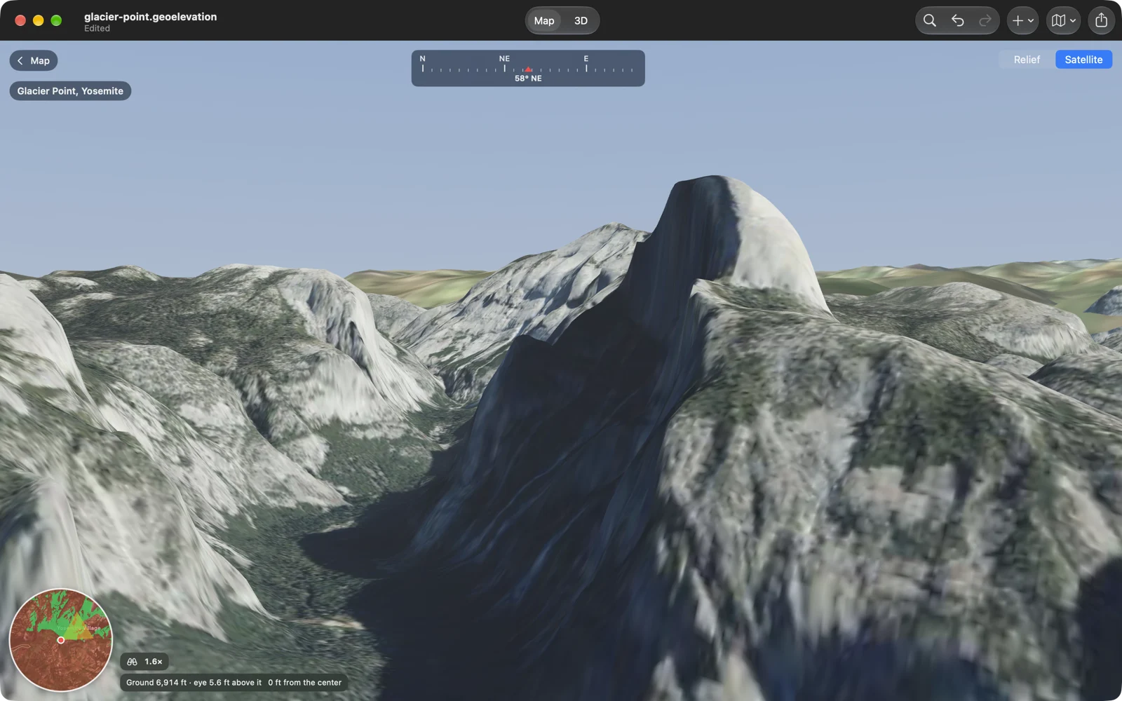
And then the obvious next step: go and stand there. Look puts you at the circle’s center, on foot, at the true height of the ground. The land around you is drawn at its real scale and lowered for the curve of the Earth, with the land beyond the circle as the skyline. It opens facing the way the most is in view. From Glacier Point, look east-northeast and Half Dome is across the valley.
Walk with W A S D on the Mac, or tap where you want to go on the iPhone and iPad. Zoom in up to 12 times and the ground sharpens where you look, in shaded relief or satellite imagery. A compass runs along the top and a mini map shows the cone of your view over the green and red.
And
- A new print sheet and PDF report: a sharp profile with its units, tables with headings, page numbers, and a path’s line of sight with its verdict.
- On the Mac, a welcome window with the sample, a new profile and your recent documents.
- Document icons draw the ground each file carries.
- In English, German, French, Spanish and Japanese, as before.
Geo Elevation is one purchase for iPhone, iPad, Mac and Apple Vision Pro, with no account and no subscription; if you bought the Mac-only edition, all of this arrives in it as a free update. The Geo Elevation page has the Glacier Point circle and the path from Charlotte to Mount Mitchell to download, ready to open. And if you have a question the app can’t answer yet, the contact form is where this release came from.