GPX Explore 2.0: draw it, fix it, keep it whole
Ever since 1.5 taught GPX Explore to read a whole file, the question has been the same one I ask myself every time I open a recording: can I fix this? Cut the drive to the trailhead off the start. Delete the point where the watch lost the sky and put me in the middle of a lake. Join Saturday and Sunday into one tour. Or, before a trip, draw the route I want to walk and see how much climbing it hides.
Version 2.0 says yes to all of it. GPX Explore is now a GPX editor, on the Mac, the iPhone and the iPad, and it is the same editor on all three.
See it in action
Recorded in the app. Interface shown in English.
Draw a route that follows the trail
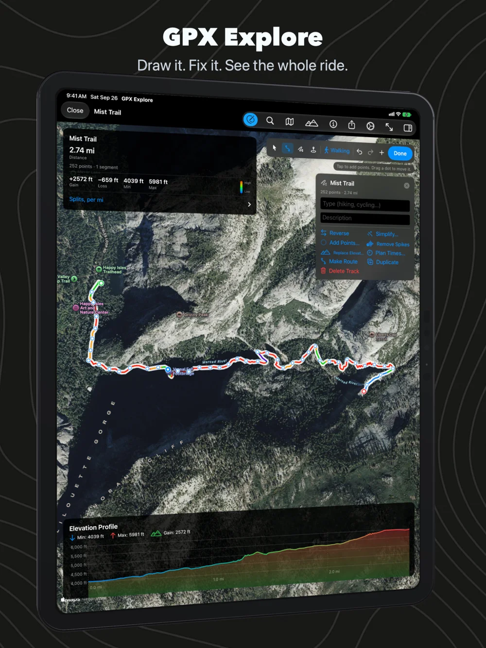
Start a new document and the map is yours: click where the route starts, then where it goes. You can draw straight lines, or pick walking, cycling or driving and let Apple Maps find the way between your clicks along real paths and roads. A click beside the trail lands on the trail, the way it does in a route planner, and if you drag one of your points somewhere else, the legs on either side are worked out again. Above are three clicks in Yosemite: Happy Isles, the Vernal Fall footbridge and the top of Nevada Fall. The route follows the Mist Trail’s switchbacks, and the chart already knows it climbs 2,500 feet in under three miles.
That elevation comes from the same place Geo Elevation gets its profiles: a 30 m terrain model of the whole world on our own server. Every point you draw is looked up a moment after you draw it, so the colours on the map and the numbers on the card are right while you are still deciding where to go. When there is no path at all, trace freehand, with a mouse, a finger or an Apple Pencil.
Fix a recording
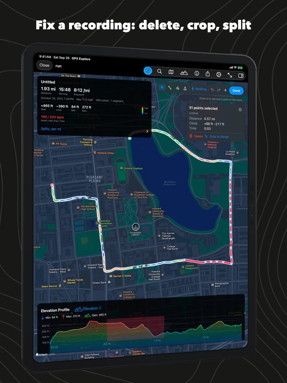
Drag across the chart, or pick two points on the map, and that stretch of the track lights up in pink with its distance, climb and time. Delete it, crop the track to it, or split the track at a point and keep both halves. The rest of the toolbox is the one I kept reaching for in other tools:
- Reverse a route, with its times mirrored so the pace still makes sense.
- Simplify ten thousand points to the few hundred a bike computer accepts, with the count shown as you move the slider.
- Remove single-point GPS spikes, found by the detour they make and the speed they would need.
- Replace a barometer’s drift or a phone’s noisy altitude with the terrain model.
- Shift every time in a track when a watch had the wrong clock, or give a planned route times at your pace, slower uphill and faster downhill, for devices and apps that want a timed track.
- Join tracks, merge segments, turn a track into a route and back.
- Drop, drag, name and describe waypoints, with a symbol that other apps understand.
Everything is one step of undo, including a drag, and on the Mac the Track menu and a right-click on the map put all of it within reach.
Keep the file whole
The part of an editor you never see is the part I spent the most care on. A GPX file carries a lot beside the line: a Garmin watch’s heart rate and power, the track colour BaseCamp set, the comments on a waypoint from 2001, the name of the app that wrote it. An editor that quietly drops what it does not understand is worse than no editor. GPX Explore writes back everything it read, each app’s extensions with their own namespaces, and a file you open and save without changing anything is written back byte for byte. Before shipping, every sample file we have was read, written and read again with nothing lost, and what GPX Explore writes was checked against the official GPX schema.
Where it came from
Most of 2.0 was not written from scratch. The way you place, drag and insert points on the map, the magnifying loupe under your finger, and the careful undo come from Geo Measure, which has been measuring fields and paths on the Mac and iPhone for years. The elevation service comes from Geo Elevation. GPX Explore is where they meet a file format that half the outdoor world uses.
Private, still
There is still no account, no sync and no tracking, and opening and looking at a file still sends nothing beyond the map tiles Apple Maps draws: for the map in the app, and for the small map behind each GPX file’s icon in Files on the iPhone and iPad. Drawing is the one thing that asks for help: the coordinates of the points you draw go to our elevation server for their height, and, when you ask to follow paths or roads, the two ends of each leg go to Apple Maps for directions. The elevation lookup has a switch.
Looking at any GPX file stays free, as it always was. The editor is GPX Explore Pro, one purchase inside the app that covers the Mac, the iPhone and the iPad; it is also what keeps the elevation server answering. GPX Explore is in English, German, French, Spanish and Japanese.